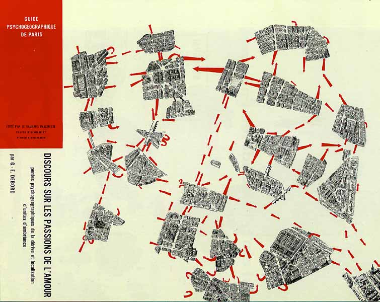
Guy Debord, 1955 (?) "Psychogeographic guide of Paris: edited by the Bauhaus Imaginiste Printed in Dermark by Permild & Rosengreen - Discourse on the passions of love: psychogeographic descents of drifting and localisation of ambient unities"
| An example of mapping of atmospheric
unities of a city on the basis of ideas of the international Lettrist and
Situationist movement. The map of Paris has been cut up in different areas
that are experienced by some people as distinct unties (neighbourhoods).
The mentally felt distance between these areas are visualized by spreading
out the pieces of the cut up map. By wandering, letting onself float or
drift (dériver is the French word used) each person can discover
his or her own ambient unities of a specific city. The red arrows indicate
the most frequent used crossings between the islands of the urban archipel
(seperated by flows of motorized traffic).
|
|
Guy Debord, 1955 (?) "Psychogeographic guide of Paris: edited by the Bauhaus Imaginiste Printed in Dermark by Permild & Rosengreen - Discourse on the passions of love: psychogeographic descents of drifting and localisation of ambient unities" |
| This page belongs belongs
to a series of pages on the principles of 'Literary-Psycho geography' by
Tjebbe van Tijen/Imaginart
Museum Projects: |