


X
X
Hedy Ellis Leiter, age 7, draws the world. s. "Educators are living in a dream world if they assume young children understand that the earth is round," write Alan Lightman and Philip Sadler. Even many fourth graders who say the earth is round often "picture a flat part where people live in the interior of the ball. Others draw the earth as a giant pancake or as a curved sky covering a flat ground." [p.5-6]
The equal-area Peters projection: ". The cause celebre of the Peters projection led to an outburst of polemical righteousness in defense of "professional standards." But ethics demand honesty. The real issue in the Peters case is power: there is no doubt that Peters' agenda was the empowerment of those nations of the world he felt had suffered an historic cartographic discrimination. But equally, for the cartographers, it was their power and "truth claims" that were at stake. We can see them. in a phenomenon well-known to sociologists of science, scrambling to close ranks to defend their established way of representing the world." (Brian Harley) [p.58-61]
Everything mapped here is permanent. On what time scale? ): "Cultural features are especially subject to change. If the maps are to have a reasonably long useful life, the features portrayed must be restricted, to some extent, to relatively permanent objects" is all Thompson ("Maps for Americans: Cartographic Products of the U.S. Geological Survey and Others", 1972) has to say about it; and though this may explain why the birds in my backyard don't show up on the West Raleigh Quadrangle, the remark is otherwise of the surpassing vagueness we have come to recognize as an attribute of the ... objective. [p.82]
Mapped here from the Bloomfield Hills and the Mack Avenue areas of Detroit are things the U.S. Geological Survey overlooks: dead shrubs and trees, broken bottles, paper, litter, bicycles, tricycles, scooters ... (From the Detroit Geographical Expedition and Institute, FieU Notes: Discussion Paper No. 3, The Geography of the Children of Detroit, Detroit, 1971.) [p.83]
A television weatherman points to a map. At the same time, it points back to him, establishing and emphasizing his modernity, sophistication, and thus his reliability. In turn, this flatters our sense of self-esteem for having selected this station over others. This map is all but consumed by its rhetorical functions. [p.114]
The map as a focusing device between the domains of extra- and intrasignification: the map gathers up the constituent signs governed by the codes of intrasignification so that they will be able to act as signifiers in the sign-functions governed by the codes of extrasignificationwhich specified them in the first place. [p.116]
A spatio-temporal map of the bus trip, and a planar projection in which the temporal dimension has been collapsed to zero thickness. Space emerges as the product of synchronization (temporal flattening) and the closure of movement. [p.130
The ethnogenesis of hillsigns. The hypothetical precursor is what we saw exemplified in Mixtec and Aztec. [p.153]
The train goes up the mountain. Note profile of hill sweeping across page, others in background. From Marian Potter, The Little Red Caboose, illustrated by Tibor Gergely: The second half of the book brings a mountain, and its defining characteristics, into the very foreground of the story: As the reader's voice and arm, rising with every iteration, relentlessly emphasize the direction taken, the illustration forever weds it to the mountain. (...) On the child the combined impact of text, heightened and inflected vocal rendering, supportive gestures and illustrations is tremendous (...). [p.164-165]
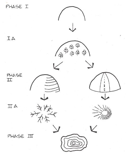
Ontogenetically, the hillsign unfolds in parallelism and mimicry the ethnogenetic sequence, with evident variations. The child's hill in Phase I is "curtained" in Phase IA before splitting in Phase II into a shaded hill(at left) and a foreshortened hill (at right). These develop in Phase IIA into either or both hachure signs illustrated before "maturing" into contours in Phase III. [p.178]
Surrealist map of the world. (From Vanetes, Brussels, June 1929.) [p.183]
This Mixtec sign for San Vicente Pinas consists of a hill and butterfly, expressing San Vicente's Mixtec name, yucu ticuvua, that is "hill of the butterfly". (Redrawn from Plate 109 of Mary Elizabeth Smith's Picture Writing from Ancient Southern Mexico, University of Oklahoma Press, Norman, 1973.) [p.183]